![]()
![]()

iTowns is a Three.js-based framework written in Javascript/WebGL for visualizing 3D geospatial data.
It can connect to WMS/WMTS/TMS servers including elevation data and load many different data formats (3dTiles, GeoJSON, Vector Tiles, GPX and much more). A complete list of features and supported data formats is available on the wiki.
It officially targets the last two major versions of both Firefox, Safari and Chromium-based browsers (Chrome, Edge, ...) at the date of each release. Older browsers supporting WebGL 2.0 may work but we do not offer support.

The official documentation is available here. It contains tutorials to help you start using iTowns, and an API reference. You can find more informations on its contribution here.
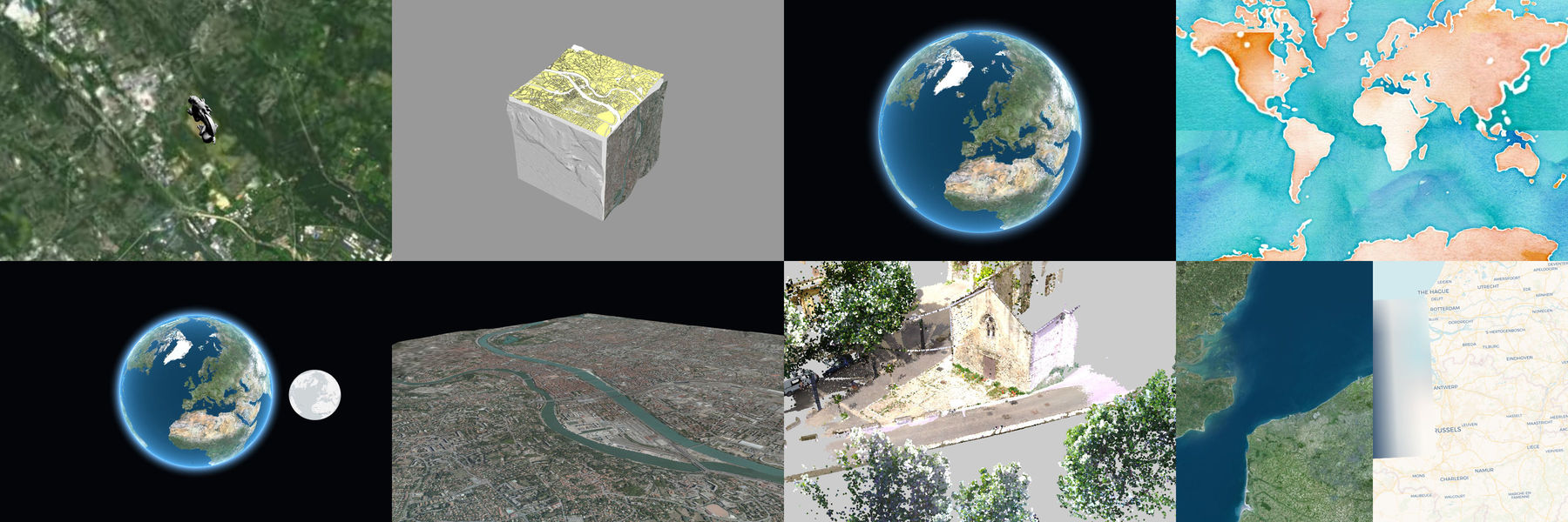
Official examples can be viewed here. Some examples available:
- Globe with WFS data
- Plane mode with Vector Tiles
- 3D effect using scene postprocessing
- Globe with split rendering
Examples can be run locally using either npm or Docker. Both methods serve them on port 8080.
Requires Node.js (LTS version recommended).
git clone https://github.com/itowns/itowns.git
cd itowns
npm install
npm startRequires Docker.
git clone https://github.com/itowns/itowns.git
cd itowns
docker build -t itowns .
docker run -p 8080:8080 itowns
Alternatively, you can build and run directly from a remote branch of itowns in a single command:
docker run -p 8080:8080 $(docker build -q https://github.com/itowns/itowns.git#<branch>)Replace
<branch>with the desired branch name (e.g.master,dev).
Once the server is running, the examples are available at http://localhost:8080/
You can use it through npm (the preferred way) or download a bundle from our github release page.
In your project:
To use all iTowns features, install itowns package :
npm install --save itownsimport { Coordinates } from 'itowns';
const coordinates = new Coordinates('EPSG:4326', 88., 50.3, 120.3);
// change projection system to pseudo mercator
coordinates.as('EPSG:3857');To import Widget features
import { Navigation } from 'itowns/widgets';

const viewerDiv = document.getElementById('viewerDiv');

// Create a GlobeView
const view = new itowns.GlobeView(viewerDiv);

// Add navigation widget
const navigation = new Navigation(view, {
    position: 'bottom-right',
    translate: { y: -40 },
});
iTowns is currently moving to a monorepo organization and to a segmentation in sub-modules, allowing to import only some of itowns functionalities. Current itowns sub-modules are:
- @itowns/geographic:
npm install --save @itowns/geographic
This package contains the ES5-compatible sources of iTowns, up to date with the latest release.
If you're using a module bundler (like wepback), you can directly write
require('itowns') in your code.
Alternatively, we provide 2 bundles (ESM and UMD) you can directly include in your html files
UMD exposes itowns in window:
<script src="node_modules/itowns/dist/itowns.umd.js"></script>
<script type="text/javascript">
    const  coord = new itowns.Coordinates('EPSG:4326', 3.5, 44);
</script>
/!\ Please note that this UMD bundle also contains the peer dependencies.
iTowns EMS bundle must import in importmap and use in module script.
<script type="importmap">
{
    "imports": {
        "itowns": "node_modules/itowns/dist/itowns.js",
        "three": "https://unpkg.com/[email protected]/build/three.module.js"
    }
}
</script>
<script type="module">
    import * as THREE from 'three';
    import * as itowns from 'itowns';
    const  coord = new itowns.Coordinates('EPSG:4326', 3.5, 44);
</script>See our release page. Note that there isn't a lot of support for older version of iTowns, we highly recommend to use the last release everytime.
If you want to try some features or bug fixes that are planned for the next release, we provide a @next version of itowns. You can install it as such :
npm install --save itowns@nextTo switch back to the version to date with the latest release, you need to run :
npm install --save itowns@latestIf you are interested in contributing to iTowns, please read the CONTRIBUTING guide and the CODING guide.
iTowns has been redesigned from this early version.
iTowns is dual-licenced under Cecill-B V1.0 and MIT. Incorporated libraries are published under their original licences.
See LICENSE.md for more information.
iTowns is an original work from French IGN, MATIS research laboratory. It has been funded through various research programs involving the French National Research Agency, Cap Digital, UPMC, Mines ParisTec, CNRS, LCPC and maintained by several organizations along the years (IGN, Oslandia, AtolCD, CIRIL Group). It has also received contributions from people listed here.
iTowns is currently maintained by IGN and CIRIL Group.
Contributions in any forms and new contributors and maintainers are welcome. Get in touch with us if you are interested :)
The governance of the project is open and explicited here.
![]()
![]()