How to remove latitude labels in x axis in cartopy 0.18 #1530
Description
Description
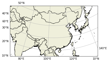
When I test the beta version of 0.18, I find some weird behavior in the new gridliner labels. While I can fix most of them by digging into the code, one thing I can't change is that there are sometimes latitude labels in x axes and longitude labels in y axes. Is there any way to disable this behavior?
Code to reproduce
import cartopy.crs as ccrs
import matplotlib.pyplot as plt

lamber_crs = ccrs.LambertConformal(central_longitude=105)
ax0 = plt.axes(projection=lambert_crs)
ax0.set_extent([70, 140, 15, 52], crs=ccrs.PlateCarree())
gl = ax0.gridlines(draw_labels=True, dms=True, x_inline=False, y_inline=False)
gl.top_labels = gl.right_labels = False
gl.rotate_labels = False
ax0.coastlines(resolution='10m')
plt.show()
Traceback
Full environment definition
python 3.7cartopy 0.18b2
Operating system
Cartopy version
conda list
pip list